- Home
- Tours & Trips
- Day Trips From Rotorua
- Tours From Rotorua
Tongariro Crossing - Will Your Body Stand Up to The Test?
The Tongariro Crossing Journey & Logistics - Approach, Shuttles, Food, Clothing, More Tips
Tongariro Crossing (21-26 min. reading) Hands up if you've ever stood at the foot of a mountain, lifted your eyes and swallowed - hard? And also when you looked up? Alarm bells rang and thoughts ricocheted inside your head. "Holy crap, what have I got myself into?" and "I could kill Suzanne." (The cousin who invited you to do this.)
2024 Important Notice: Department of Conservation has implemented a free booking system for any part of Tongariro Crossing beginning summer 2023/2024. There won't be a cap on visitor numbers initially and those who turn up without a booking will not be penalised. It will come soon though in order to better manage sustainability, conservation and cultural values.
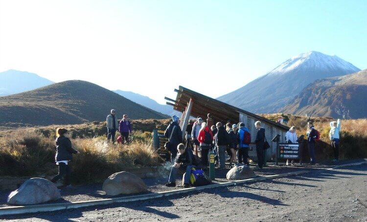 Tongariro Crossing entry point off Mangatepopo Rd. Mt Ngauruhoe (R) aka Mt Doom of Lord of the Rings fame and Mt Tongariro (L) background
Any enthusiasm you may have had leaches down your body right on out through the heels of your brand new, steel toe-capped boots. And yes, you know the boots should have been broken in but time kind of ran out. And yes, you now know that they shouldn't have had steel toe-caps. Duh!
It's daunting enough thinking about climbing Mt Tongariro - never mind
actually seeing it in full glorious technicolour alongside Mt Ngauruhoe and Mt Ruapehu.
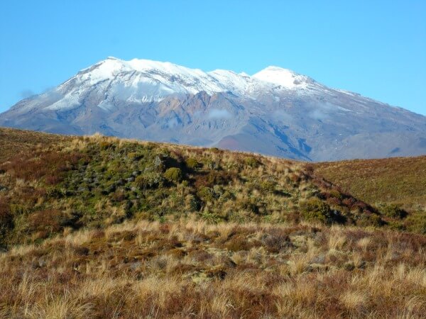 Mt Ruapehu
Another realisation slams into your mind! This is it, the point of no return, there's no going back. Well, technically you could back-track but it sure doesn't feel that way (maybe you don't mind the red-faced walk of shame.)
Great news!
Once you get going, it isn't as bad as it looks. You'll see how, as I take you through my Tongariro Crossing journey, sometimes thoughts are worse than the physical act itself, plus what you can expect to see and do. We'll finish off with the logistics around shuttles, timings, costs, what to take and other handy tips.
How the Walk Unfolded
My cousin and I drove down from Rotorua at the end of high season in April and managed to catch a perfect day. Sun, warmish down the bottom and no snow on Tongariro.
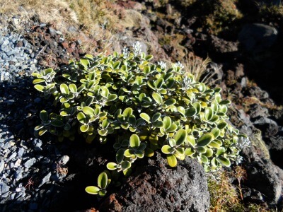 Tongariro Crossing's alpine plants
 A lot of people were undertaking the 19.4km (12+ mile) walk so
conversations, huffing and a lot of puffing floated around on the thin
alpine air. Quite a few children were walking the trail (overheard toward the
end, "Dad, I'm never going for a walk with you again." Ha!) and also a fair amount of older people.
How hard could the Tongariro Crossing be?
Pretty hard actually, or maybe it's more like tiring. You need to have a good level of fitness to take on the Tongariro Crossing
and I'm inclined to think, fit or not, most people are very tired at the end, I know I was.
We had really good conditions though and didn't have to battle high winds, driving rain, large hailstones, snow or fog. Always keep in the back of your mind that the weather can change in an instant on this mountain. It's often a case of having to turn back for safety's sake to try again another day.
If You're Asthmatic
Kamilla shared in the Facebook Comments below how tough it was for her as a severe asthmatic. Although she trained beforehand to help her lung capacity, it still didn't prepare her for this walk.
Her heart rate
got up to 185bpm at times and she had to keep stopping to take puffs
of her inhaler. She knew going in it would be hard and take her longer, and that she would do it. It took her 9h:45m to complete. —Way to go Kamilla!
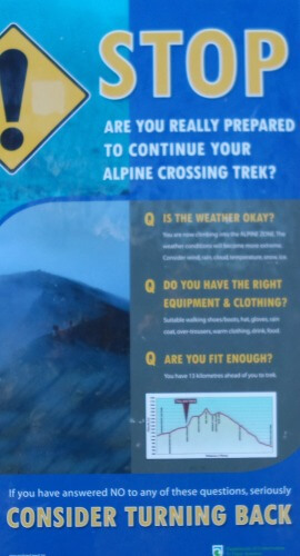
Isn't this sign above a wonderful welcome - not - as the climb begins to incline rather steeply up the Devil's Staircase. Gulp - this is a serious business.
What if the weather turns (it does up there you know), have I got enough clothes, enough food? What if it begins to snow and I can't see? I'll wander off the track only to fall into a 1,000ft ravine. I'll be turned into a human Popsicle and not found for 5,00yrs (it happened to the Frozen Iceman in the Ötztal Alps). This is so not a good sign. Ha, get the pun?
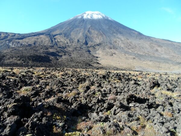 Mt Ngauruhoe again viewed from the lava trail
The Tongariro Crossing takes a good 6-7-8hrs
7h 59m in our case, not that
I'm being nit-picky of course - hey, one minute is one minute. Included
in that time were
numerous stops to take photos, catch a breath (lots of times, it was
comforting that everyone else did this too), have munchies, drinks and
lunch, and to soak up the incredible views and scenery. With that, plenty of
fuel and
fluid is needed to make it through in good shape.
Something else to be mindful of
Vertigo! Yes, and in the most inconvenient places. Lift your head to
look at the mountaintops and whoops, there you go again, listing towards
the side of a particularly steep ridge.
Find a Place to Stay
Here's the surprising thing though
You don't actually see Mount Tongariro. Like a chameleon, it blends into the surrounds. I mean it's not in your face
like Mount Ngauruhoe (the steep pointed one). Now that one? You see! Apparently it's a parasitic cone of Tongariro. Gross, does that conjure up visions of nasty creatures erupting out of your skin too?
As an aside, you may want an additional challenge. A climb to the summit of Ngauruhoe is a side trip of 1-1½hrs from the saddle between Tongariro and Ngauruhoe with 30min to come down.
(Not the place to lose your footing as a friend found out. He began sliding which turned into running, then he couldn't stop himself from going head over heels a number of times. He only stopped by smashing into rocks and whacking his head quite badly. Somebody was smiling down on him because he was okay.)
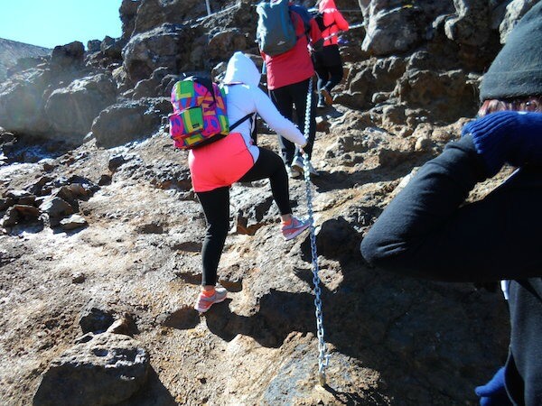 Ascent up to the Red Crater (the crossing's high point)
With the Tongariro Crossing you climb hill after hill. Each time the top is crested, there's an even more formidable one in the distance. Back-lit against the skyline, an army of ants march relentlessly upwards.
Here go those crazy-making thoughts again. Am I seeing right? No, surely those aren't people. You've got to be [insert favourite swear word] kidding me! Maybe it's another track. Please, please, pleeease let it be another track. No such luck because sure enough, that's where we would be headed next. Every time it looked hugely daunting but by just assuming the position and planting one foot in front of the other we eventually got there.
The South Crater (below) brought some relief as it was a fairly flat, windy
expanse of desertness (my own word). I half expected to see tumble-weeds barrel past like in the old cowboy movies.
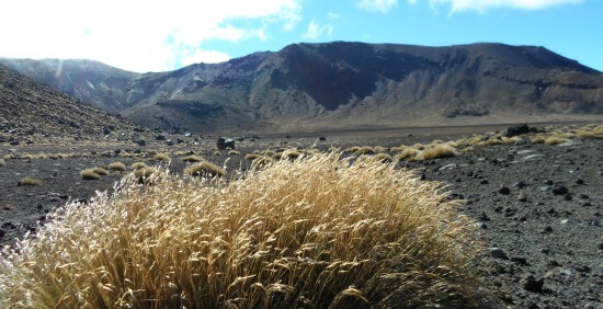 South Crater looking towards the ants!
The weirdest thing. I actually felt compelled to sing Climb Every Mountain', and wanted to do it full voice. I did manage to rein myself in and kept it low. The Sound of Music has never been my thing, at all, so I can only put it down to the alpine air.
It's hard to grasp where the Tongariro Crossing top is until you reach the Red Crater (1886m), and a sign says it's the highpoint. Initially, I didn't realise that it wasn't the top, top.
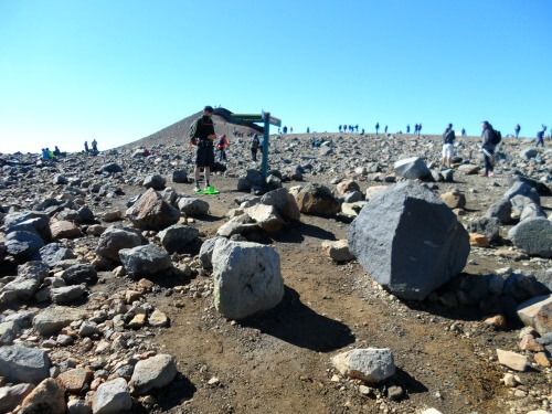 The Tongariro Crossing highest point - see what I mean about ants? And these are close.
The Tongariro Crossing Summit itself is another (easy) 1hr 20m return side trip
from the Red Crater. This is all on top of your 7-8hrs. We thought about
it - for a minute. Maybe another time.
Being up so high on volcanoes would, I imagine, be similar to standing on the moon or some other far-flung planet.
Like those other planets, Tongariro has been ripped apart again and again over preceding millennia. Left behind are deeply scored ravines coloured in brilliant shades of scorched, red and black fused scoria.
It's also been left a battered, barren wasteland that, contrarily, is beguiling with the harshness pocketed by moments of great beauty. Why else would people keep on climbing it?
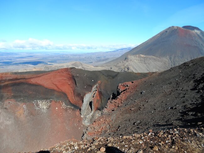 Parts of the Red Crater with Ngauruhoe in the background
Broken rock litters the unforgiving ground everywhere but is quickly forgotten with one look over the side. This is where the Blue and Emerald Lakes make their grand appearance.
And it's true
The Emerald Lakes are vivid pops of colour totally at odds with being nestled in such a brimstone hell-pit of desolation. All that's missing is a fiendish red devil with an evil laugh and a three-pronged fork beckoning you down, down, down.
Against a
backdrop of hazy mountain ranges in the distance, the Blue Lake is situated in a crater quite a bit higher than the Emerald Lakes. To complete this surreal picture? Fluffy clouds floating by below eye level. Unbelievable!
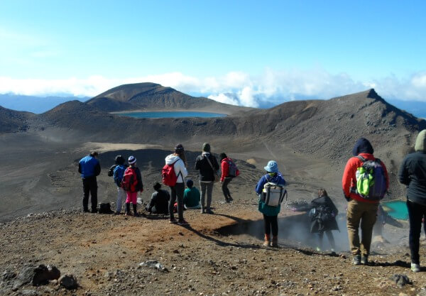 View from Tongariro Crossing highpoint overlooking the lakes
You can see people walking down a ridge, left-hand side of the pic below, to the Emerald Lakes. It looks relatively easy doesn't it? Don't be fooled. When you're there, it's super steep, and each side of the track is a long way down.
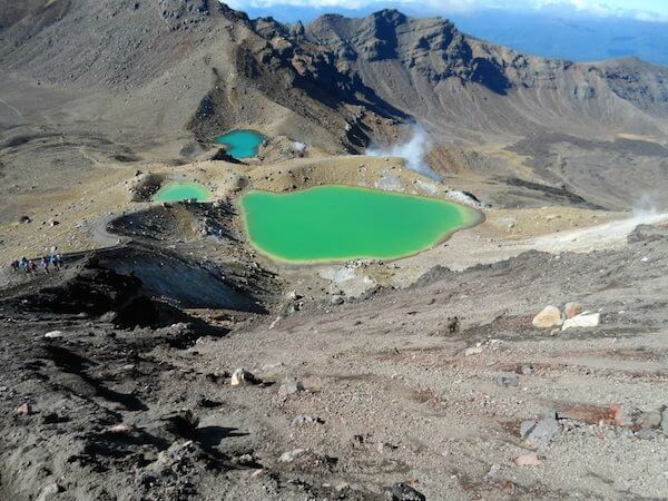 Emerald Lakes on the Tongariro Crossing
Loose, steaming black scree signals the beginning of the descent. Now that is scary - not the steam, the scree that has you sliding two or three steps for every one taken. One wrong step? It's all over rover, welcome to hell (can you hear that evil laugh).
Along with plenty of others I ended up on my backside a couple of times and cousin Sue just about lost it with an attack of cramp. Do you realise how hard it is to manage cramp while you're sliding? A narrow ridge isn't a good place to get it.
According to NZ Mountain Safety this ridge is where the most 'injuries and search and rescues happen on this mountain.' Check out their 7.37min video below because it will help with familiarisation and other things to take into consideration.
Once safely at the bottom you have to climb again to get to the Blue Lake (below). It's a strange feeling looking at a lake perched up higher than you are.
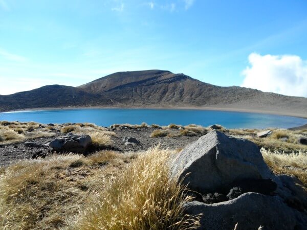 Tongariro Crossing Blue Lake
The track runs alongside this lake before yet another climb up through a pass where Lakes Rotoaira (foreground) and Taupo (looking like the sky) in the far background come into view. We'd made it to the other side!
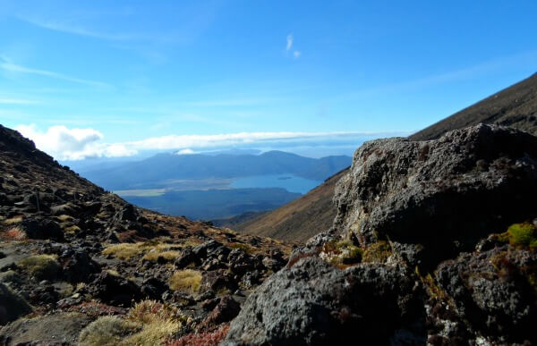
From now on the tussock-sided track is solidly downhill, including hundreds if not thousands of steps all the way (hours of it yet) to the Ketetahi Carpark.
Of
interest here, apart from the unforgettable views, are the Te Māri craters (below). They
erupted in a cloud of steam and ash in 2012 and appear on the right-hand
side of the hill. The area is hot with steam still billowing out of the craters.
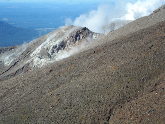 Te Māri Craters
Dodgy knees & blackened toenails
Now if you've got dodgy knees, this is where they will majorly kick in so Walking Poles are a must have.
One other thing? Toenails slamming into the front of your boots, every step of the way. I know, right! Not something anyone cared to alert me to prior. As I write this page, a couple of weeks later, one blackened toenail is on it's way out, the poor thing.
Since then I've spoken to others who've also lost toenails on the Tongariro Crossing, sometimes multiple ones. I thought only runners got this condition, now I know otherwise.
One way round it would be to carry light, open-toed sandals to slip on for this section.
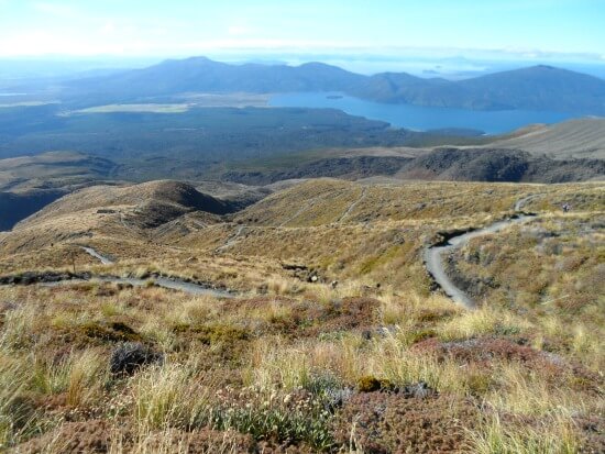 Down, down, down
I'm not saying this happens to everyone though. Heck, people ran downhill... effortlessly. If only.
I've decided to make a recommendation to DOC to turn this section of the Tongariro Crossing into a luge track. That would make it so much easier... and a whole lot more fun too. You can see by the pic above that it would be great for luging.
And if that doesn't happen and I want to walk this trail again, a helicopter on standby would be the way to go.
Of rumblings & running
Walking in native bush towards the bottom, a sign appears that reads along the lines of: if you hear any rumblings, do a runner. A runner! What do you mean do a runner? I've just walked 19km over volcanoes and now you're telling me I may have to do a runner.
It was obviously because of water and rocks blowing out of the Te Māri Craters. Grasses were flattened in places and smaller trees and shrubs had been smashed to pieces by one or more of the large rocks lying on the ground. And only recently too by the looks of it. It was like a war zone.
Tired or not? The slightest hint of a rumble and you wouldn't have seen me for dust. What? If the size of the rocks and the smashed shrubbery was anything to go by, you wouldn't want to be hanging around either.
After about 5min there was a collective sigh of relief at the next sign saying we were out of the danger zone.
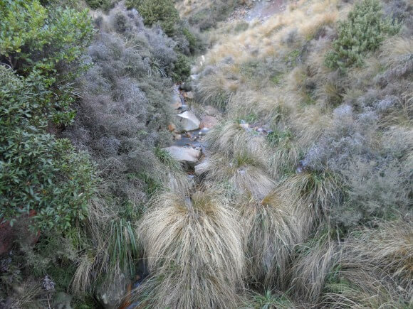 Tussock and native shrubbery on the track downhill
A short while later and we were finished. Done! Our bodies had stood up (mostly) to the Tongaririo Crossing Test. It was so lovely to sink down onto a bench at Ketetahi Carpark, albeit rather briefly.
Shuttles and buses were everywhere so we hauled our weary backsides up to go locate ours which would take us back to the car at Mangatepopo Rd (this has now changed as you will see below).
The driver laughed when telling us people are mostly seized up by the time they're dropped back at their vehicles. What a meanie. But it's true. And we were.
Tongariro Crossing Logistical Information
During the October - April high season parking is now limited to 4hrs at both Mangatepopo and Ketetahi carparks. This makes it impracticable to use them for the crossing. That leaves us having to pay for transportation usually in the form of a shuttle. Easy right? Not even!
View Rotorua to Tongariro Crossing Managatepopo Road start in a larger map
Tongariro Crossing Shuttles - Decisions, Decisions
Direction You Approach the Mountain From
First up for consideration, people approach the Tongariro Crossing trailhead of Mangatepopo Road from a variety of directions. The ones named here are where you can catch shuttles from, apart from Waiouru (see note below).
- West of Mangatepopo trailhead: National Park, Whakapapa, Raetihi, Ohakune, Taumaranui, Waiouru
- East of Mangatepopo trailhead: Taupo, Turangi, SH46 Lake Rotoaira Road, Waiouru
Either direction is applicable to both north and south bound traffic, generally passing through one or more of the places mentioned. Your choice of shuttle/bus operator will be dependent on your approach direction.
Probably the easiest and least stressful thing to do is use one of the smaller family-owned shuttle operators if you can. From the reviews, some of them go way above and beyond for their customers.
Note: For those travelling north on SH1 passing through Waiouru, the easiest way to manage this is to travel to Rangipo (about half-way between Waiouru and Turangi, turn left onto SH46 and catch a shuttle at one of the shuttle carparks on that road.
Budget
Next consideration is your budget. Although the walk itself is free the shuttle/bus services attract a cost. If self-driving and wanting to save money you have the option of a one-way journey. Anything else means a return journey. Your options are:
- Drive and park up on Lake Rotoaira Road near the end-point of the walk (private carpark or on the side of the road), catch a shuttle from there to the start. On finishing the walk, walk another 800-1000m to get back to your vehicle. Approx cost $25-$35. Downside? The road can be hellishly dusty for the walk back to your vehicle in summer and many shuttles and buses will be on it at the same time. Depending on who you use, the transportation can be either shuttles or the large buses.
- Stay or park up at a nearby town/village/Lake Rotoaira Road (but further away), and catch a return shuttle and if that's the case...
- This goes for both of the previous options. Do you want a larger operator with fixed times, you pay less, and be in with the masses hitting the trail at the same time or,
- Do you want a smaller group operator who is flexible on timings and offers a more personal service but costs more
- This goes for both of the previous options. Do you want a larger operator with fixed times, you pay less, and be in with the masses hitting the trail at the same time or,
Whichever shuttle company you use, make sure to book your tickets online to ensure you have a record of the
transaction. Some people have run into problems with verification when booking
and paying over the phone. Get Your Guide in the banner below is easy to use and cancellations are fully refunded right up to 24hrs beforehand.
Shuttle Companies for Tongariro Crossing
WESTERN Approach Shuttle Services
The Northern Explorer train travelling between Auckland and Wellington stops at both National Park and Ohakune. It operates Mon, Thu & Sat southbound from Auckland, and Tue, Fri & Sun northbound from Wellington. From either place you can access a shuttle to the Tongariro Crossing. National Park would be the more popular.
As well, Intercity Buses have a number of drop-off points at National Park.
Tongariro Crossing Shuttles
Website: https://tongarirocrossingshuttles.co.nz/
Phone: +64 (0)7 892 2993
Email: info@tongarirocrossingshuttles.co.nz
Pickup times & costs (approx): National Park - Park & Ride @ Railway Station (Findlay St) return 6am, 7am, 8am, 9am, 10am. Includes pickups at Ski Biz @ The Alpine Centre (10 Carroll St), YHA National Park Backpackers (4 Findlay St), Mountain Heights Lodge SH4, Wood Pigeon Lodge (Raurimu), Mangahuia Campsite SH47 (pickup at roadside 10min later), $40. Ketetahi one way 7am, 8am $?
Summit Shuttles
Website: http://www.summitshuttles.co.nz/
Phone: 0800 828 294
Email: Contact form
Pickup times & costs (approx): Park & ride transport hub, cnr. Findlay St & Station Rd, National Park, return 5.45am, 7am, 8.15am $40 adult, $25 child
Tongariro Track Transport
Website: http://www.thetongarirocrossing.com/
Phone: 0800 872 258
Email: info@thetongarirocrossing.com
Pickup times & costs (approx): 21 Carroll St, National Park, return 5.45am, 7am, $40 - park securely at onsite complex
Dempsey Buses
Website: https://dempseybuses.co.nz/
Phone: +64 (0)6 385 4022
Email: info@dempseybuses.co.nz
Pickup times & costs (approx): Ohakune/Raetihi return 7am $50, Whakapapa Village return 7am, 8am, $40, National Park park & ride car Finlay St & Station Rd 7.30am $40
EASTERN Approach Shuttle Services
If you're travelling by bus, Intercity passes through all the places mentioned. The first two shuttle companies mentioned below have a private carpark option on Lake Rotoaira
Road SH46. This is where you can park up - be it in the carparks or on
the side of the road (going with the flow of traffic), catch a ride to
the start of the walk at Mangatepopo then hike about 1km back to your
vehicle at the Ketetahi finish point.
Tongariro Expeditions
Website: www.tongariroexpeditions.com/
Phone: 0800 828 763
Email: info(@)tongariroexpeditions.com
Pickup times & costs (approx): Taupo return 5.20am $70, Turangi
return 6.10am $50, SH46 Lake Rotoaira Road private carpark one way
6.30am, 7.30am, 8.30am $35, Tongariro Holiday Park return 6.40am $35,
Tongariro Crossing Mountain Shuttle
Website: www.tongarirocrossing.com/
Phone: 0800 865 226
Email: bookings(@)tongarirocrossing.com
Pickup times & cost: One-way shuttle from Lake Rotoaira Road
private carpark 6.30am, 7.30am, 8.30am, Cost (approx): $35
Backyard Tours
Website: www.backyardtours.com/tongariro-alpine-crossing
Phone: 022 314 2656
Pickups
and costs (approx): Taupo return 5am, $60, Turangi return 5am, 6am,
7am, 8am, $50, Lake Rotoaira Road SH46 Private carpark return 5.15am,
6.15am, 7.15am, 8.15am, $35
Active Outdoor Adventures
Website: www.activeoutdooradventures.co.nz/
Phone: 027 228 4831
Pickup times & costs (approx): Turangi return 5.30am, 7am, 8.30am, $50, 806 Lake Rotoaira Road SH46 return 5.45am, 7.15am, 8.45am, $35
Notes: Maximum group size 26 people
Turangi Alpine Shuttles
Website: http://www.alpineshuttles.co.nz/
Freephone: 0508 427 677 Mbl: 027 232 2135
Email: Contact page
Pickup times & costs (approx): Turangi iSite return 6am, 7.30am, other Turangi pickup points 10min later, $50; Ketetahi one way 7am, 8am, Extra summer timeslots 8.30am, 9.30am $35
Hopefully that's broken it down for you somewhat. But, that's only the start. You'll still have to do your own research on the various companies. Read the reviews because you soon get a sense of who you would be happy to use. All it takes is a bad experience such as your transport not waiting for you, overbooking, no communication, or one of the many other things that can go wrong, and your day is ruined.
You might need a place to stay too?
Food | Clothing | Toilets | Other Tips
I couldn't believe how some of the young people were dressed. You would have thought they were popping out for a Latte at their local cafe. Light tops barely big enough to wipe your nose with, short shorts, sneakers (not even running shoes) and no food to speak of. What the....?
It leads one to think how divorced from nature we must live to be so blasé about her vagaries and power. What do you think?
Take with you:
- Food ie. protein rich sandwiches (warms you up), fruit, nut bars and the like, chocolate (very welcome) and chippies (I craved the saltiness by the time I got to the top which I think comes from sweating - without realising it's happening because it's so cold). Hot soup in a small flask would be wonderful at the top too.
- Fluid as in water, I took two 750ml bottles but only drank one. (No water on the trail is drinkable). A friend who has previously walked the trail, told me about a fellow walker who took hardly any water. What did this person do? She drank not only her own water but my friend's and somebody else's as well. Don't be that person. In the facebook comments below people drank varying amounts from one bottle like me to one commenter drinking 3L.
RTS Tip: I'd also picked up a small bottled Berry Smoothie and that one little drink was dynamite, so refreshing and a real pick me up. If there's a next time, I would get a bigger one. - Boots and woollen type socks (I loved my John Bull boots because they kept my feet cosy, and the support, especially going down the scree and around rocky bits, was wonderful). Many people wore running or walking shoes.
- Hats, gloves and scarves as you get up into the colder parts
- Make sure your backpack is a manageable weight because you're carrying it for a long time.
- Woollen, polypropylene or merino base clothing because cotton won't keep you warm when you get sweaty, and you will. Even though it's cold, you'll be hot from the exertion. These are standard items of clothing in NZ during winter (outdoor shops like Kathmandu will know what you're talking about). They wick moisture away from the skin so you don't get that cold, wet, yucky feeling like you do with cotton t-shirts or normal undergarments. The upshot is, you hold onto your body heat.
You can also buy polyprops (as we call them) at Farmers and even The Warehouse (not as good a quality fabric but fine just the same) - look out for sales because they can be expensive. Polyprops are cheaper than Merino but also more breathable, hug your body better (do get looser as you move) and are quicker to dry. A girlfriend always buys Merino because she's got sensitive skin.
- Rainproof coat and over-trousers keep you snugly and warm not
only with rain but the icy winds. I borrowed this gear off a mad
fisherman of a brother (thank goodness for brothers - they come in handy
sometimes) as it's not like I go on major hikes every day.
- Sunscreen - yes, Sue was sunburned on one side of her face. I had to laugh because it looked like she'd been slapped.
- A first aid kit, of which the plasters came in handy for a blister.
- Map and compass - I have to admit that we didn't take these. We were lucky as the visibility was excellent.
- Cellphone for emergencies (no coverage in the valleys but crystal clear reception up the top - it felt quite surreal when I received a couple of calls while having lunch up top) and GPS is great to have too.
When it comes to winter, whole different story. On first reading up about the Tongariro Crossing, the words 'take an ice axe and crampons' (what the hell is a crampon) freaked me right out. And we were going right on the crossover period! Iceman, iceman. Enough said.
Long story short, prepare for all conditions.
- Toilets are located at the Mangatepopo Carpark, Mangatepopo Hut, Soda Springs, Ketetahi Hut and Ketetahi Carpark. Quite a distance is covered between Soda Springs and Ketetahi Hut so time it well.
- Most important! Take toilet paper. There are none in the toilets.
Handy Links for Further Reference
- www.doc.govt.nz - Department of Conservation
- Bookmark the MetService for up to date weather reports at Tongariro National Park to keep for your own travel dates.
In closing
If you're a novice to this type of hiking, like I was, you'll have a better understanding of what's involved now and some of the challenges you can expect to face - and maybe some you weren't expecting.
I worried about the fitness, only getting up to 13km
max beforehand and not doing enough hills. As a gauge for you, I
normally walk 3-4 times a week (including lots of local hills) and go to
the gym 3 times a week. My cousin Sue trained up a lot beforehand, in
excess of 6hr hikes.
Was the Tongaririo Crossing trek testing? For sure. But like I said, it was totally manageable taken in bite-sized chunks.
My question is, are you ready to put your body through the Tongariro Crossing test?
If you do, I'd love to hear back if you got the urge to break into song. Some of your crazy-making thoughts would be great to hear about too (please tell me I'm not the only person to think like this).
Happy Hiking.
Take a detour to Rotorua if you haven't visited us already :)
- Home
- Tours & Trips
- Day Trips From Rotorua
- Tours From Rotorua
